Garmin announced the addition of new features for the Garmin Pilot application for Android and iOS mobile devices. Garmin Pilot 6.2 for Android incorporates approach chart overlays on the moving map, enhancements to stadium TFR’s, glide range ring, logbook tracks and more, while the 9.1 version of Garmin Pilot for iOS adds a new high resolution basemap, worldwide gridded winds and a streamlined Connext devices page. Within the iOS version, pilots can also access aircraft performance profiles, checklists and weight and balance data for additional aircraft types.
Android 6.2
6.2

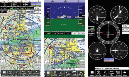
Chart overlays
Pilots that utilize Garmin FliteCharts now have the option to overlay instrument approach procedures (IAPs) on the moving map. The chart overlays may be displayed in North Up or Track up while flying, offering a seamless transition from the enroute to approach phase of flight.
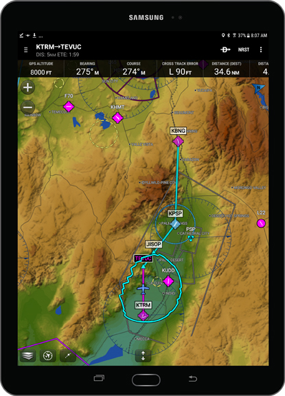 Glide Range Ring
Garmin Pilot offers pilots the option to display a glide range ring on the moving map within Android mobile devices. The glide range ring is depicted as a cyan ring around the estimated area that can be reached by the aircraft in a best glide configuration. Range is based on Best Glide (VG) speed and the glide ratio entered by the pilot within the aircraft profile, which then utilizes the aircraft’s altitude and wind to determine range ring distance. The option to shape the glide range ring for rising terrain that may interfere with the aircraft’s glide range is also available.
 Additional features for Android mobile devices
- Temporary Flight Restrictions (TFRs) specific to stadiums incorporate unique coloring to denote when the TFR is active or inactive. Blue TFRs depict the event is between 1-7 days in the future, yellow TFRs indicate the event is within 24 hours and red TFRs depict the TFR is active.
- GPS-based tracks can now be embedded within a logbook entry, which displays a geo-referenced map of the associated flight so pilots can easily recall recent flight history and tie it to their electronic logbook within Garmin Pilot.
- Automatic downloads file updates and next cycles of existing data and charts and are automatically downloaded to a mobile device as they become available so pilots always have the most up-to-date information.
- Flight plans can be manually sorted and stored either alphabetically or in a customized fashion as determined by the pilot.
iOS 9.1
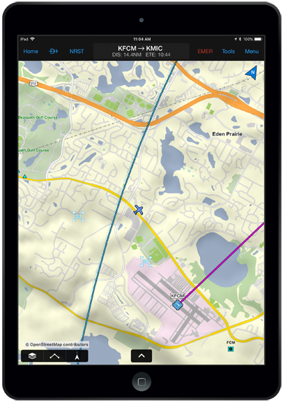 OpenStreetMap
Utilizing OpenStreetMap, pilots now have access to high resolution, detailed street maps for improved situational awareness. OpenStreetMaps display street names, parks, railways and other pertinent landmarks such as golf courses and schools. These high resolution maps are available as part of a standard Garmin Pilot subscription and once downloaded to a tablet, are accessible while on the ground and in-flight.
 Additional features for iOS mobile devices
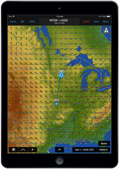
- Garmin Pilot now incorporates gridded winds aloft forecast data based on the Global Forecast System (GFS) weather model.
- The Garmin Pilot aircraft library has been expanded to include new performance profiles, checklists and weight & balance data for Beechcraft, Cessna, Cirrus, Van’s aircraft and more.
- A new Connext Devices Page displays the associated Connext-enabled device along with symbology that depicts the specific features it supports.
The latest versions of Garmin Pilot for Android and iOS are available immediately. For additional information, visit: www.garmin.com/aviation.