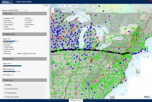
 FltPlan has added a web-based Map Builder that takes the route from a flight plan and displays all of the user-defined layers and options on a single map – an industry first. Map Builder allows users to build a single, custom map for their route using 12 background maps, 12 map layers (including Airports and Fuel Prices), 6 weather layers (including Winds Aloft, SIGMETs/AIRMETs layers), and additional route viewing options. With an array of customizable features, FltPlan users can build the map that they would like to view.
Items on FltPlan’s Map Builder are user defined and can be defaulted to best fit the individual piloting needs of whomever is using the map. Some pilots may want to view certain things upon opening their map, for example, an IFR pilot may want to include SIDs/STARs, while a VFR pilot may only want to include a Fuel Price or Weather Radar overlay. The Map Builder makes this possible by allowing users to set and save different map layers, weather layers, METAR layers, and route options to automatically display every time the map is opened.
Because the Map Builder is integrated with FltPlan.com, the route of flight is automatically displayed on the map when the Map Builder is initially opened. This eliminates both the need for a pilot to create a route directly on the map and any concerns associated with having to transfer the route they want to fly into a fight planning program. “This free feature addresses a need that has not been met by any flight planning website,” says Sarah Wilson, Principal and Director of New Technology and Business Development for FltPlan. “Consolidating the weather and base maps for pilots to display with their route allows our users to get a complete picture of pre-flight conditions. We know that the Map Builder will become an indispensable tool for our users,” added Wilson. “This is one more step in FltPlan’s ongoing mission to simplify the flight planning process for our users.” Wilson goes on to say, “FltPlan strives to meet the flight planning needs of its users while keeping the cost of flying down for general aviation. We would rather have our users spend money on what’s important, like fuel or a better mobile device.”
The responsive design of the Map Builder allows it to fit any screen, which makes this program accessible from any device. The Map Builder can also be used on multiple devices at one time. There are no add-on fees, licensing fees, or in-app purchases required to use flight planning tools such as the Map Builder. The Map Builder, along with helpful instructions, can be accessed from any Navigation Log on the FltPlan.com website.


