
The inspiration for writing this tutorial came from when I was a flight instructor at the uncontrolled Skymanor airport (N40) near Pittstown, New Jersey from 2016 to 2020. In those days, because the president owned a golf course not far away, there would routinely be a presidential TFR that included Skymanor in its outer ring. This was common knowledge among most local pilots, but not all!
This airport had a wonderful restaurant that drew pilots there on weekends for the traditional “hundred dollar hamburger.” It was amazing how many times a pilot would simply take off and fly to N40 without looking at a VFR section chart in ForeFlight to see if a TFR was in effect.
It was not uncommon to see an airplane on downwind leg being followed by a military helicopter because that pilot had busted the TFR. I even saw a Piper Cherokee get passed on the downwind leg by an F-16 fighter due to a TFR bust. Because of these incidents, I felt a tutorial on VFR flight planning was in order.
Doing My Homework Before Takeoff
Conducting thorough preflight planning means flying proactively instead of reactively. Having to look up what pattern altitude is, or the CTAF frequency, when approaching the destination airport is the very definition of flying reactively. Because of TFRs that change almost daily, the days of spontaneously jumping into your airplane with no preflight planning and heading off for the hundred dollar hamburger have long passed. So, let’s plan a VFR flight proactively, and do it right!
NOTE: I recommend that the reader log onto ForeFlight and follow our progress from there. I will be using all current data such as weather, surface winds, weather radar, TFRs, NOTAMs, etc., for May 25, 2024 at 8 pm local, or 0000Z.
My fictitious Cessna 182 is based at Blairstown, New Jersey, 1N7. I am planning to make a night, VFR flight from Blairstown to the New Garden airport near West Grove, Pennsylvania (N57) to visit a pilot friend. Even though this is a very short flight, as the reader will see, doing my homework will mitigate several threats I will encounter. With this as a setting, let the flight planning begin.
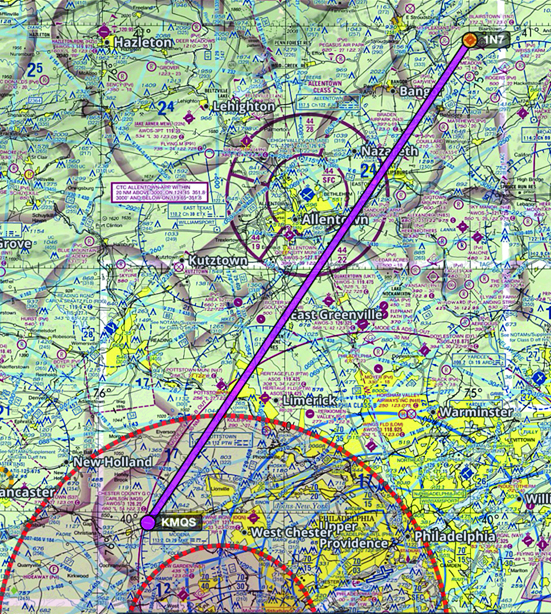
Since I will be flying VFR, I can simply enter 1N7 and N57 into the Flight Plan window on ForeFlight and look at the direct route. See photo below.
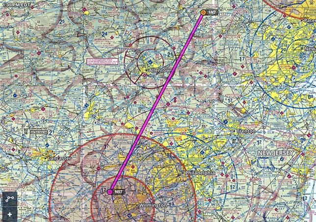
Oops!! That route will take me directly into the inner ring of a presidential TFR! This is why pilots simply must do the most basic flight planning before slipping the surly bonds of Earth.
After notifying my friend that I cannot land at N57, he agreed to drive to the Chester County Airport, KMQS, and meet me there. See photo below.
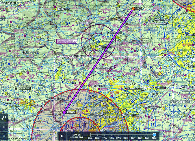
While I will still be landing within the TFR, it will be in the outer ring which, if I follow the rules, will be legal. More on this later.
My next step in preflight planning will be to check the weather radar on ForeFlight and the TAF for KMQS to see if this flight can be made safely under VFR. See TAF below. The radar shows rain and a few thunderstorms in the area moving east, which the TAF has predicted.
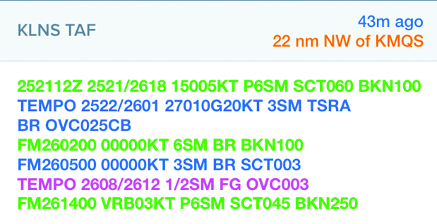
Departing Blairstown at 0000Z on a flight of 72 nm flying my Cessna 182 will have me arriving at about 0030Z. The TAF shows that from 2200Z to 0100Z winds 270 at 10 gusting to 20 knots and 3 miles visibility and thunderstorms. Note the word TEMPO before the forecast of storms. TEMPO means there is a 50% chance or greater of a thunderstorm in that time frame.
However, at 0100Z, the TRSA will have abated and replaced with winds calm with 6sm visibility and BKN clouds at 10,000 feet. With this forecast, I will delay my departure 30 minutes, or until 0030Z so that I will arrive at or after 0100Z. Checking the current radar verifies that storms are in the vicinity of KMQS but moving east.
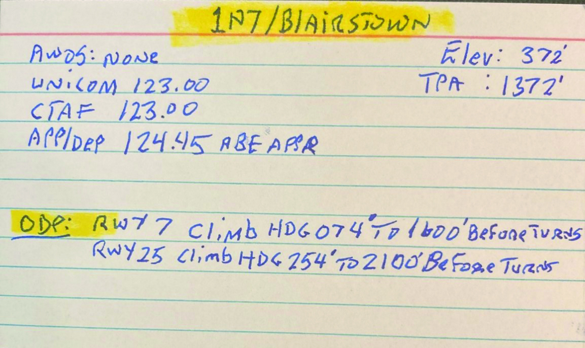
The next step in preflight planning is to research the departure and arrival airports and record what I find on 3×5 index cards or similar venue. I will start with Blairstown, 1N7.
Tapping on the Airports tab in ForeFlight and entering 1N7, I write on my airport data card (see below) the following information:
- AWOS/ASOS: None
- CTAF/Unicom frequency 123.00
- Field Elevation: 372 feet
- Traffic pattern altitude for my return flight: 1,372 feet
- Tapping on the NOTAMs tab I see that there are no NOTAMs. And lastly, I will need to find out who I will call after takeoff to receive flight following after departure.
Who To Contact for Flight Following
Finding out who to call for flight following after taking off from Blairstown is done by tapping on Info on the Airports tab. Under Departure, I see both New York and Allentown Departure Controls, but because our route will take us over Allentown, KABE Approach on 124.45 is the frequency I will use to request flight following after taking off.
Using Flight Following
Pilots should always get flight following when leaving the vicinity of the departure airport. Once contact has been made with ATC, flight following automatically clears you into Class D airspace, Class C airspace, and the outer ring of a TFR. However, even with flight following, you still need to request a Class B clearance from the ATC controller you are working with prior to entering the outer ring of Class B. Other than that, with flight following, there is no such thing as an airspace bust. If you are headed straight for the inner ring of a TFR, the controller will advise you of this and suggest a heading to avoid it.
Another reason to always request flight following is in case of an emergency, such as an engine failure. Flying along and not in contact with ATC, who do you call to declare an emergency if your engine suddenly quits? 121.5 is an option, but you will first have to enter that frequency into your comm radio. Then, you will need to establish contact with ATC all while dealing with an engine out forced landing. And finally, you will need to tell someone precisely where you are making a forced landing, something ATC would already know with flight following.
Is There An Obstacle Departure Procedure?
Since it will be a night takeoff, I want to know if there is an Obstacle Departure Procedure for my takeoff runway. ODPs tell instrument pilots on an IFR flight a heading to fly and altitude to climb to avoid terrain that may be obscured by clouds. At night, that same terrain will be obscured by darkness. Flying an ODP will guarantee the VFR pilot of terrain and obstacle clearance when taking off at night.
You do not need to be on an IFR flight plan to fly an ODP.
While flying the ODP is not mandatory, even for instrument pilots on an IFR flight, its use will greatly enhance the safety of the VFR pilot departing at night. When climbing to the altitude prescribed in the ODP, always do so at Vy since outclimbing the terrain is the goal.
The first step in determining if an ODP exists is to check the surface winds to determine which runway I will be using. Blairstown has one runway, 7 and 25. I note that 1N7 does not have a published ASOS or AWOS, but area airports show light winds generally out of the south making Runway 25 the active.
On the Airports tab, to see if an ODP exists for Runway 25, I tap on Procedure, Departure, and TAKEOFF MINIMUMS. Under Blairstown, I see the words DEPARTUE PROCEDURE. The ODP for Runway 25 is to climb on heading 254 to 2100 feet before making any turns. Subtracting the field elevation of 372 feet from the ODP altitude of 2100 feet shows that a climb of 1728 feet AGL before making any turns is required to be assured of terrain clearance at night. I will copy this on my airport data card for quick reference.
I have proactively done my homework for safely departing Blairstown at night. Now I will check out the Chester County Airport and make a second airport data card.
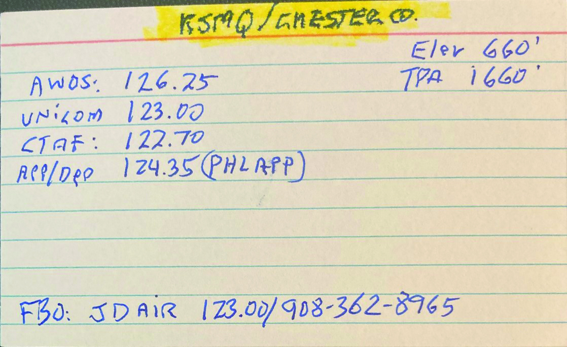
On ForeFlight I enter KMQS in the Airports tab and note the following:
- AWOS: 126.25
- Unicom/CTAF: 122.70
- Departure/Flight Following: 124.35/ KPHL Departure
- Airport elevation: 660 feet
- TPA: 1660 feet
- NOTAMS: None
I will enter all of this on my KMQS airport data card.
With all of the preliminaries complete, it’s now time to analyze the route I will be flying. My planned cruise altitude is 4500 feet. See photo below. (Note, radar returns are off to declutter the diagram.)
After departing Blairstown, the first thing I notice is that my route will take me through the Allentown Class C airspace. A cruise altitude of 4500 feet will put me just 100 feet above the sector I will be traversing, and very close to the center where Class C extends all the way to the surface. A slight deviation from course or altitude will put me in Class C airspace.
However, this is of no consequence because I will be receiving flight following which automatically clears me into any part of Allentown’s Class C airspace. See chart below.
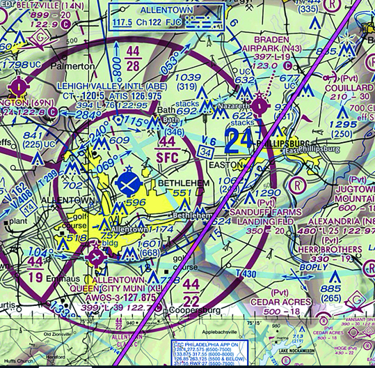
The next item of interest is that the Chester County Airport, aka KSQM, is within the outer ring of a TFR. But again, like the Allentown Class C, with flight following, I will be legally cleared to enter the outer ring of that TFR, but with one caveat. When the KPHL approach controller tells me that frequency change to CTAF is approved, I must NOT squawk 1200, but must keep the discreet code issued for flight following all the way to touchdown. Changing the transponder to VFR prior to landing will result in a call from the FAA, and a possible violation filed.
There are other items for planning that were not covered such as the winds aloft and minimum fuel required, which for a night arrival, is 45 minutes. On a much longer flight, these items would be important enough to warrant discussion.
What Would Have Happened Had I Taken Off With No Preflight Planning?
- I may not have thought about getting flight following. If I did, I would not have known who to call and on what frequency.
- There would most likely have been a thunderstorm in progress for my arrival at KSQM.
- I might not have known about traversing the Allentown Class C airspace.
- I would not have known that a climb of 1728 feet AGL before making any turns was required to guarantee clearance from obstacles that would have been obscured by darkness.
- I might not have known I was flying into a TFR.
Why I Use Airport Data Cards
Airport data cards condense in one place everything I need to know about my departure and arrival airports. They also reduce my cockpit work load so that, at a glance, I will know if there is an ODP and what the procedure is for night, VFR departures. Researching the airports also forces me to check for things such as right traffic for a certain runway, or who to call on departure to get flight following.
Hand flying a single engine airplane with no autopilot and having to look up what pattern altitude is, or what the CTAF frequency is, unnecessarily adds a distraction from the task at hand, which is flying the airplane and looking for traffic. With an airport data card clipped to my knee board, all I have to do to find that information is to look down at the card.
Some pilots use their iPad for this information, but that entails several taps on the screen to locate information that could have been known and recorded prior to departure. In addition, using the iPad to find pertinent information unnecessarily adds a distraction and increases cockpit work load.
Conclusion
As usual, it is my sincerest desire that my esteemed readership will find this article to be informative and helpful. For questions, comments, or corrections feel free to contact me at Jturpin782@aol.com

