 Garmin Pilot also adds Nearest navigation feature and more
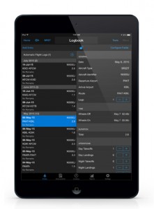
OLATHE, Kan. /July 16, 2015/Business Wire — Garmin International Inc., a unit of Garmin Ltd. (NASDAQ: GRMN), announced electronic logbook capabilities built-in to the Garmin Pilot application for iPad/iPhone and seamless integration with flyGarmin. While flying with Garmin Pilot, the logbook feature provides automatic record keeping of commonly recorded data pertaining to each flight. Information such as date, total duration of each flight, number of takeoffs and landings, route and more are all conveniently sorted and saved for easy reference across Garmin Pilot devices and within flyGarmin. Built-in redundancy also allows pilots to make manual logbook entries via the flyGarmin website or Garmin Pilot app, where both entries are automatically synced and stored to display the same information. Additional capabilities include the ability to record endorsements, track flight currency, generate historical flight reports and more. In addition to electronic logbook documentation, Garmin Pilot now incorporates Nearest navigation functionality so pilots can see at-a-glance, the nearest airport, navigational aid, airspace or facility, relative to their location.
“We continue to pack more features and capability into Garmin Pilot to bring our customers an all-inclusive application that gives pilots the information they need from pre-flight planning and enroute navigation, to now include post-flight logbook documentation,” said Carl Wolf, vice president of aviation marketing and sales. “We’re excited about these free, cloud-based synchronization services between flyGarmin and Garmin Pilot, which provides pilots with a simplistic and powerful time-savings tool – all built into a single application.”
Automated Logbook
Integrated within Garmin Pilot, logbook provides pilots with an automatic and convenient way to maintain a consistent log of their flights, while accessing in-flight navigation information within one application. While on takeoff roll, Garmin Pilot detects a change in airspeed and altitude, which initiates the logbook function to automatically begin recording. Pertinent information such as date, duration, total flight time, route and the number of flight segments are automatically recorded and logged within Garmin Pilot, creating a provisional logbook entry for the pilot to review and accept. Pilots may modify the provisional log entries or manually add flight information into the logbook as needed. Additional data fields may also be manually entered to specify aircraft type and identifier, hobbs and tachometer times, as well as pilot-in-command, solo, cross-country, actual and simulated instrument flight time. For added reassurance the logbook data is automatically stored on the flyGarmin website, as well as within the Garmin Pilot application. Likewise, logbook entries made within flyGarmin are also saved and synced within Garmin Pilot.
Logbook provides even more opportunities for record keeping, including a tab for pilot certificate and currency endorsements. Within the Garmin Pilot application, flight instructors and other designated authorities may document flight reviews, Instrument Proficiency Checks (IPC), pre-solo knowledge test sign-offs and more. Logbook also provides pilots with quick and easy access to flight currency information. A dedicated currency tab identifies FAA, EASA and TCCA day/night and instrument currency types so pilots can quickly reference whether or not, for example, they are current to fly passengers or at night. For easy reference, logbook automatically generates a report to display past flight information by day, month and year.
Nearest Navigation Feature
Now included at the top of the main menu, Garmin Pilot incorporates nearest navigation functionality to give pilots the option to locate the closest airport, NAVAID, intersection, user waypoint and more, relative to their location. Pilots can also quickly locate Visual Reporting Points (VRPs), Air Route Traffic Control Centers (ARTCCs) and their associated frequencies, as well as nearest airspace for added situational awareness. To assist with the decision-making process, pilots are provided with a ruler line that identifies the selected airport on the moving map, as well as course and distance information relative to the location of their aircraft.
In addition to these new capabilities, Garmin Pilot calculates and displays density altitude information on the weather tab within the airport page. This calculation is automatically displayed within Garmin Pilot so pilots can view at-a-glance, density altitude data, which is critical to aircraft performance. An enhanced distance-measuring tool has also been modified to allow for easier use and functionality within the moving map page.
Garmin Pilot 7.4 for iOS is expected to be available next week during EAA AirVenture as a free update, providing existing customers access to these latest features. For new customers, Garmin Pilot is available in the Apple App Store as a free download for the first 30 days. After the 30-day trial period, customers may purchase an annual subscription of Garmin Pilot starting at $74.99. FlyGarmin logbook documentation is a free service and will be available on flyGarmin.com. Visit the Apple App store to download Garmin Pilot and visit www.garmin.com/aviation for additional information.
Garmin’s aviation business segment is a leading provider of solutions to OEM, aftermarket, military and government customers. Garmin’s portfolio includes navigation, communication, flight control, hazard avoidance, an expansive suite of ADS-B solutions and other products and services that are known for innovation, reliability, and value. For more information about Garmin’s full line of avionics, go to www.garmin.com/aviation.


