By Joel Turpin
Introduction
Sometime in the late 1990s, the FAA switched from using American-based weather terminology to that used by the World Meteorological Organization, or WMO, which is the ICAO standard. That change brought us odd sounding terms like METAR, TAF, and more. Younger pilots who started out using this brave new way of describing aviation weather had no difficulties learning it. But the gray eagles, like me, had to learn a whole new set of strange abbreviations and terminology. It was not unlike transitioning from analog cockpits to glass.
METAR stands for Meteorological Aerodrome Report – a compact snapshot of the weather conditions at an airport or weather station, updated every hour. It needs to be said that not all the information posted on METAR is for pilots. Many government agencies, such as the National Weather Service, glean the numbers posted on our METARs for their records and for meteorological research. Other agencies need more accurate data than what pilots need, so there are mysterious numbers that have probably never been explained before.
Note: I will highlight in black all information that is not for pilot consumption but may cause confusion.
Reading A METAR
So, let’s begin reading a METAR with an explanation of all of those strange terms and numbers that no one taught you in any other training venue.
Here is a basic METAR for Punta Gorda, Florida. We will examine what the terms and symbols mean line by line.
The interpretation is as follows;
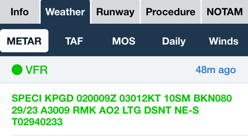
SPECI stands for SPECIAL and it means something weatherwise has recently changed that cannot wait for the normal hourly report. KPGD 020009Z means the report is for Punta Gorda, issued on the 2nd of the month at 0009 Zulu, or 8:09 pm local time. Winds from 030 at 12 knots, visibility 10 statute miles, broken clouds at 8,000 feet, temperature of 29 degrees C, dewpoint 23 degrees C, altimeter 30.09 inches of mercury. The AO2 simply means the weather data was taken automatically by a non-human device that is able to record precipitation (AO1 means the device cannot record precipitation).
The next symbols are LTG DSNT NE-S which means lightning has been detected in the distant northeast through south. This might be the reason a special METAR was issued. When the term DSNT appears, it means the phenomenon reported is more than 10 nm away but less than 30 nm away.
On the bottom line are the temperature and dewpoint with an accuracy to the nearest 10th of a degree. This is described officially as Additive Automated Maintenance Data and is there for use by non-aviation entities. So, T02940233 means the temperature is +29.4 degrees, where the zero means the temperature is positive (1 would indicate a negative temperature) and the dewpoint is +23.3 degrees C. These numbers are not intended for pilot use. They appear for the National Weather Service only.
Now, let’s try interpreting another METAR

It was issued on the 29th of the month at 0235Zulu, or 10:35 pm local time, by an automatic recording device. Wind is from 060 degrees at 3 knots. Visibility is 10 statute miles. -RA means light rain. FEW120 indicates a few clouds at 12,000 feet, temperature of 26 degrees C, dewpoint of 24 degrees C, altimeter is 30.10 inches of mercury. RMK AO2 states that all weather data was recorded automatically by a device that can record precipitation (A02). RB means rain began at 0157Z, ended at 09 past the hour and began again(B) at 46 minutes past the hour.
Now for the data that may cause confusion because the numbers do not make sense to the average pilot. The explanation is only published here to help pilots discern what is, and is not, intended for aviation use and can be ignored.
SLP means Sea Level (barometric) Pressure is 1019.1 millibars, P000 is Precipitation is zero inches since the report was posted, 6000 is data collected by some unknown government agency, temperature is a plus (a 0 indicates above freezing while a 1 means the temperature is below freezing) 26.1 degrees C, dew point is plus (0) 24.4 degrees C. The numbers 50008 are again, an Automated and Maintenance Data reading which the NWS or another government agency harvests but does not concern pilots.
Some of the Automated Maintenance Data includes 24- hour precipitation, duration of sunshine, 6 hour maximum and minimum temperature, sensor status, etc., none of which pilots need to know.
Now let’s analyze a more complex METAR.
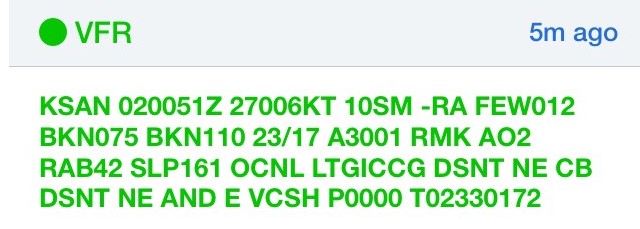
This one is a METAR report from San Diego, California (KSAN). The lack of the word AUTO means the data was recorded manually by a human, and not by a computerized device.
It was issued on the 2nd of the month at 0051Zulu (8:51 pm Pacific Daylight Time). The wind is from 270 degrees at 6 knots, light rain, a few clouds at 1200 feet (the leading zero in 012 is a place holder for clouds at or above 10,000 feet), broken clouds at 7500 feet, broken layer at 11000 feet. The temperature is plus 27 degrees C, dewpoint 17 degrees C, altimeter 30.01inches of mercury. RMK says that A02 is, again, an automated weather recording device capable of measuring precipitation.
RB42 shows that rain began at 42 minutes past the hour. SLP 161 is an abbreviated barometric pressure in measured in millibars and does not apply to pilots. OCNL LTGICCG DSTNT NE means Occasional Lightning in Clouds and Cloud to Ground DSNT NE, or distant northeast, while CB DSNT NE AND E means Cumulonimbus clouds are present in the distant northeast and east somewhere between 10 and 30 nm away. Next is VCSH, which means showers in the vicinity.
Another possible lightning detection abbreviation is LTGCA which means Lightning Cloud to Air.
You might also see LTGCM and LTGMH – Lightning Cloud to Mechanic and Lightening Mechanic to Hangar… just kidding!
P0000 TO2330172 are Additive Automatic Maintenance Data for the National Weather Service and other government agencies, and not meant for pilots. P0000 means no precipitation has been recorded in the time frame the METAR was posted, and T02330172 means the temperature recorded was a plus (0 means above freezing) 23.3 degrees C and a dew point of plus (0)17.2 degrees, none of which applies to pilots.
All of the information highlighted in black is only explained here to sate the curiosity of those who ponder what all of these odd numbers and symbols mean. But keep in mind, they are not for pilot consumption.
Conclusion
I hope this explanation of how to read a METAR has solved the mystery of what some of those strange numbers and symbols mean. I will publish a follow up tutorial on how to read a TAF in the near future.

